Guide to Wreck Fishing
Wreck Fishing – on the drift
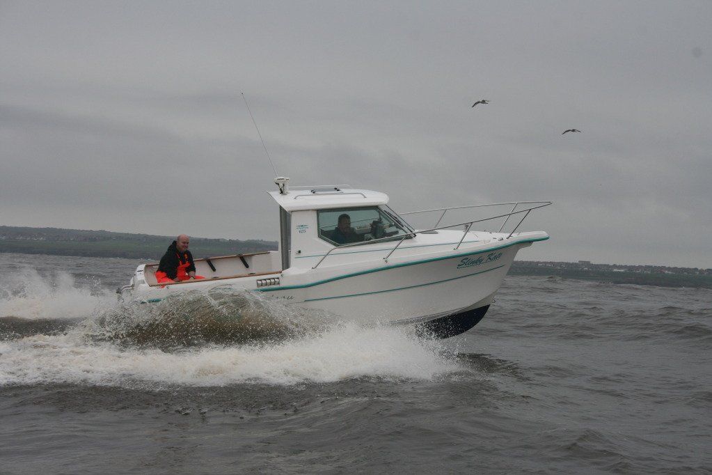
Drifting a wreck is without doubt the most common type of boat fishing in our North East Waters, It`s common practice with virtually all the charter boats and probably 80%-90% of private boats (although probably not all to the same degree of success).
Although some may agree and others disagree, for what it`s worth this is my method of hopefully teasing out that record fish from the depths and entanglement of structure below.
Wrecking can be split into two fundamental sections.
Although some may agree and others disagree, for what it`s worth this is my method of hopefully teasing out that record fish from the depths and entanglement of structure below.
Wrecking can be split into two fundamental sections.
a) Getting there and finding it
b) Fishing it !
b) Fishing it !
Firstly we start with essential equipment (assuming the basics of a boat fit for the purpose and safety equipment to suit have already been established) There are only two pieces of equipment required to pinpoint a wreck :-
A GPS System
There are so many on the market now and prices are continually falling, essentially it should be a GPS Chart Plotter with a screen size somewhere around 4 or 5 inches square.
I use a Garmin GPS MAP230 which I`ve had for about 8 years now. It`s a greyscale screen of 7.1 inches diagonal rather than colour but serves me well.
I use a Garmin GPS MAP230 which I`ve had for about 8 years now. It`s a greyscale screen of 7.1 inches diagonal rather than colour but serves me well.
Accuracy is within about 3-5 metres on all GPS units now, so there is no need for the much talked about DGPS add on units which used to improve the accuracy some 8 or 9 years ago, since now there is no signal distortion introduced (called selective availability).

A Sounder (Fishfinder)
Again the choice of sounders is enormous and the prices are as for all electronic equipment, falling by the day. I would suggest anyone who regularly wants to search the sea-bed for wrecks or profiles or hardness outcrops should invest in a good colour sounder.
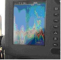
Sounders have evolved from simply being a depth indicator to now being almost a camera on the seabed. I use a Furuno FCV600L Colour Dual Frequency Sounder which has a screen size of 5.6 inches
Sounders have evolved from simply being a depth indicator to now being almost a camera on the seabed. I use a Furuno FCV600L Colour Dual Frequency Sounder which has a screen size of 5.6 inches

Section a) Finding it !
The aim is to be guided by electronic tracking and calculation within the GPS unit to the point where the wreck is thought to be and then, when there, sounding out the bottom in “Real Time Mode” to locate the structure below.
First we start with numbers, much of which are freely available from many sources be they friends, charts, diving books etc etc. Let us start with this one located some 5 or 6 miles off the Tyne piers.
Known locally as the “Border Star” Lat. 55 01.52 and Long. 1 16.21
At this point let me clear up some of the mystery of Latitude and Longitude figures.
Latitude is degrees, in our case North, from the equator and Longitude is degrees, in this case West of Greenwich (yes that is West, not E
ast).The figures shown above are in the format used by all our marine GPS systems and is in degrees, minutes and decimal minutes (not seconds). This means that the wreck we are looking for is situated 55 degrees and 1.52 minutes north of the equator and 1 degree 16.21 minutes West of the Greenwich meridian.
Begin by entering these Lat and Long figures into the GPS and marking them with an Icon of a wreck. There may well be several other methods and personal views on this but as I stated, this is “My Way”.
A wreck Icon to me means simply a location supposedly to point to a wreck which can be used by my GPS for navigation.
OK ….. Go there by navigation on the GPS and look to see what the sea bed looks like on the sounder (the method will be determined by the individuals choice of GPS system so I`ll not go into the navigation technicalities at this point .. read the handbook supplied with your GPS)
Well ? …………. what`s the result on the sounder ?
Unless your very, very lucky it`ll be almost a flat line, - Nothing !……
The reason for that is quite simple, virtually all marks passed around are those used prior to S.A. (selective availability) being switched off and are subject to an accuracy rating of some 20 metres. It may well be that they are even locations read direct from a chart and converted to lat / long readings, in essence they are indications only, to the actual position of a wreck. The task now is to search the sea bed to locate the structure.
This can be a difficult task and takes great patients. Firstly switch the GPS to plotter mode and clear the screen of any old tracks that were made getting to the position and zoom as close in as the GPS plotter will allow. Navigate to take the boat exactly over the wreck Icon and with the bow facing exactly north (using the compass for direction) slowly move the boat northwards in as straight a line as you can, all the time watching the sounder for signs of structure, and the plotter and compass together to make a straight line north. Use the 2X zoom on the sounder to give a decent chance of any wreck or structure being seen on the screen). If any bits of structure are seen on the sounder then mark them with the “Mark” button or similar on you GPS and save to memory (the name or number of this mark is totally unimportant as it now already forms part of the pattern of the wreck number you are at). Regardless of whether you have spotted anything or not carry northwards for some 50mtrs then turn as tight a circle as you can to the port (left) and run due south parallel to your initial track. Again watching the sounder screen and marking any structure you see (don`t expect a quick result). Carry on south past the original start position for some 50mtrs past the wreck icon then turn tight Stbd (Right) and repeat northwards again. Keep repeating this until you have made a grid some 50mtrs west of the original wreck Icon, then steam back to the wreck icon again and repeat the whole procedure in the opposite direction (east) to the first search pattern.
If all has been successful (and sometimes its not it takes several attempts) the end result should show a wreck Icon on the GPS plotter screen with a mark or two somewhere close around it which (and this can now be guaranteed) your boat with your GPS will be able to navigate from anywhere directly to by by plugging in the original wreck mark (still shown by Icon on screen) then when within 50 mtrs or so switch to plotter screen and move over any one of your marks around it. This WILL pinpoint the wreck EVERY time you visit.
I would suggest to all new boat owners or those trying wreck fishing in their own boat for the first time, to set aside a day or two in decent conditions (prior to getting the rods out and lines into the water) and do a scouting mission as above. Get around as many wrecks as you can and get the positions marked. You can`t afford the time whilst out on a serious fishing trip to try finding any new wrecks, you`ve got to KNOW exactly where they are first.


Section b) Fishing it !
Lets assume that the previous section has been accomplished successfully and we now have GPS with Icon marked wreck positions (estimated from charts or given numbers) and a bunch of marker points around them as previously discussed which are confirmed found wreckage points with your own GPS.
Select the desired wreck you want to fish on your GPS and steam to it. When your within 0.1 miles (a few hundred metres) switch the GPS to plotter mode and slow down to almost tick-over on the engine and approach carefully. This slow down for the last couple of hundred metres is very important, this gives the GPS time to calculate position more carefully. The GPS is constantly tracking satellites and internally calculating your position from the information it receives, it then sends information to the plotter screen to display your position as it sees it .While your running at anything up to 20kts the position it plots can be anything up to 10mtrs incorrect because of the time it`s spent calculating and displaying, especially if you have set a slow update rate to your track display. So, to get by this (and also to less spook any fish) approach the last few hundred metres as slow as you can.
Watching the plotter at (max zoom) manoever the boat until you are exactly over one of your previously marked points …… the sounder WILL I guarantee, show the wreck you have previously found. Drop the clutch into reverse and hold it till the boat stops dead in the water.
OK stop the engine (or disengage the clutch and let it tick over if that’s your preference) get to the bait box and start baiting up …… don’t worry about fishing, just sort out the bait and get your gear ready your not fishing this drift , just preparing. Ensure everyone aboard is ready then after a few minutes checking bait and rod and reel get back to the wheel start the engine and look at the plotter screen. It will show a track that runs from where you are now, up drift to the mark you started from (the wreck). This track is you indication track of how your boat is drifting in this tide on this day over this wreck in this wind. Slowly steam a course that follows this track as closely as possible, watch the sounder and you will see the wreck appear as you close in on it. Keep steaming (slowly) over the top and down the other end until you are past the wreck and back to flat ground (the wreck should still appear on the left side of your sounder screen). OK into reverse and stop the boat dead.
That’s it your ready to drop lines in, give the signal and all drop straight down over the edge of the boat. Watch to see if the line goes straight down or if it veers off in any direction due to water current, this will be a guide for your next drift.
Try to get your tackle down to the bottom as fast as you can, as it is descending you are already drifting towards the wreck and the aim is to meet the bottom just as the drift causes the sounder to show signs of structure below. Now the difficult bit, to have success in wreck fishing you must be “IN” or “on” the wreck, this is all a matter of feel constantly dropping line and retrieving so as to keep in touch with the bottom (or wreck) at all times. Of course this is also the point of high tackle losses as you catch everything down there that is waiting to grab your line, most of it inanimate such as wreckage. Hopefully also this is the point of hooking into that long awaited double figure fish as it exits from its hole in the wreck to take your bait that’s been drifting smells down tide and banging thumping weights on the wreckage waking all up.
Watch the sounder and wait till the wreck is passed (best takes of fish are usually in the shelter behind the wreck) give it a few minutes then wind in for another drift.
This is the time to re-check tackle and re-bait your hooks, you MUST have this done and all be at the ready before you go for another drift.
OK second drift, you should have found on the first drift that you may not have quite gone in the direction that you first thought, put this knowledge to good use and adjust the second drift start point accordingly. Also, did you notice your line stream off in one direction or another as you dropped down the first time? Again, put this knowledge to good use and have a little cast out up tide on the second drift trying to get your line straight up and down at the moment it contacts the bottom.
Repeat the process of drifts time and time again.
Note: every time you visit the same wreck the conditions will be different, the drift the wind the tide will all vary in direction and strength so the first drift is the most important to learn the conditions on the day.
Some days certain wrecks hold fish, others the same wrecks don’t it`s constantly changing, there only one thing for sure it`s not where the wrecks are that’s important it`s which ones are holding fish on any given day so , if you find them shhhhhh tell no-one (except me of course) …………………..
Good Luck, Norman